Community map for bikepackers to find bivouacs, water and repairs
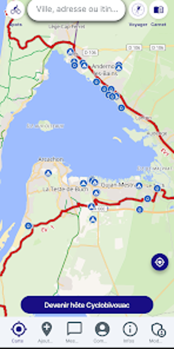
Shows a collaborative map where cyclists can discover and add bivouac sites, water points, and repair stations across major European cycle routes. Cyclobivouac, created by Sébastien Delage, targets long-distance cyclists and bikepackers who need a pared-down, travel-focused map. The app offers GPX import, manual route tracing, filtered POI searches, and an integrated messaging channel for hosts and helpers, making it a practical on-the-road reference for cycle touring itineraries and overnight planning.
What the app does for cycle touring
Cyclobivouac maps cyclist-specific resources by centering shared bivouac and camping locations, plus water and repair points on a collaborative layer. The map excludes general retail clutter, so search results return cycle-relevant POIs instead of unrelated commercial entries. This focused dataset supports planning overnight stops and locating essential services while following mapped long-distance routes.
How accurate and reliable its location data is
Community verification governs spot quality, with users adding and updating entries; the source notes that community-verified points keep listings relevant. That model means accuracy depends on active contributors along a route, which benefits regions with engaged local cyclists but may leave gaps on less-travelled axes.
Device compatibility and route workflow
Designed for Android mobile use, the app supports GPX file import and manual route tracing, so you can load an itinerary or draw one inside the interface. The connection model is native: the map and tools run on-device, and the lightweight build suits travellers carrying a single phone as their navigation and logging device.
Intended uses, limits, and community functions
Built for bikepackers and long-distance cyclists, the app aims at planning bivouacs, finding water and repairs, and arranging community hosting via integrated messaging. It is a non-commercial, ad-free project maintained as a community service, which means features prioritize practical mapping and local collaboration rather than commercial listings or advertising-driven content.
Clear choice for self-sufficient cycle tourists who value community-sourced stops
The app suits bikepackers who need a focused, ad-free map for bivouac planning and route management; its community-verified POIs and GPX import support real itineraries. Users should expect data quality to vary with contributor density and accept that the tool emphasizes cyclist needs over general travel listings. For touring cyclists who rely on peer-shared locations, it provides a usable, low-friction field reference.